The northern towns
Mornington, Mount Eliza and Mount Martha are the lived-in end of the Peninsula. The Shire's Open Space Strategy records medium density housing at 21 per cent in Mornington against 12 per cent across the Shire, and the holiday-house percentages that run above 50 in Rye and above 60 in Portsea do not apply here in the same way. The Shire's thematic history still describes the post-war housing estates and holiday houses that urbanised the Peninsula, and plenty of that stock stands in these three towns, but it sits beside houses that are occupied all year, which means the doors that stick get noticed in the first winter rather than the fifth. The work is a mix: reblocking weatherboards on clay, underpinning brick veneer on strip footings that have moved with the seasons, and on the Mount Martha slope, the engineer before either.
The ground: clay, and then granite
Two Victorian Resources Online units cover most of the three towns, and a third covers the hill.
| Unit | Where | What it means for stumps and footings |
|---|---|---|
| Bittern unit | Mount Eliza and the north-west | Fine sandy loam over a bleached zone with ironstone, medium clay from about 350 mm, sodic subsoils, waterlogging in wet periods. The clay swells in winter and shrinks in summer; holes hold water from June; timber stumps rot at the ground line. |
| Dromana unit | South of Mount Martha toward Dromana, and across to Baxter | Sandy loam over a bleached subsurface, mottled medium clay from about 450 mm. Easy digging for the first half metre, then clay that moves with the seasons and that the stump has to sit on properly. |
| Arthurs Seat unit | Mount Martha | Granite under sandy gritty loam, shallow soils on steep slopes. Tall stumps downhill in fill, rock close under the uphill side. Slope, not soil, decides the job. |
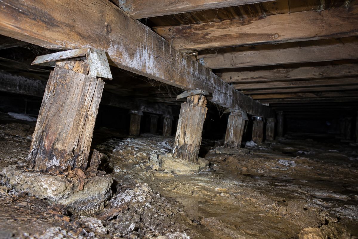
The Bureau of Meteorology's Cerberus station puts the Peninsula's rain at 712.8 mm a year on 105.5 rain days, with June the wettest at 73.5 mm and February the driest at 34.8 mm, and the older Cranbourne Botanic Gardens record to the north averaged 811.9 mm before it closed in 2020. On the Bittern clay that pattern means a swell-and-shrink cycle every year: cracks over door frames that open in late summer and close in spring, a brick veneer whose corner lifts and drops, a weatherboard whose timber stumps stand in water for three months and rot at the ground line. The answer on clay is depth, a stump that does not rot, and drainage so the subfloor dries between winters. On a brick house on a strip footing it is underpinning on an engineer's design, after the drainage is fixed, and the soil test classifies the site before the design is drawn. The soils guide goes through it.
Mount Martha, the slips and the overlays
The Esplanade at Mount Martha has moved twice in recent years. On 29 September 2020 about 30 tonnes came down onto the road, two access roads have been closed since, and retaining wall works are running from November 2025 to December 2026, according to local reporting. In November 2022 Mount Martha North beach was closed near the beach boxes after a cliff was assessed as unsafe. The planning scheme already carried erosion overlays in these towns before the McCrae landslide: EMO3 at Ballar Creek in Mount Eliza and EMO4 at Tanti Creek in Mornington. After the Board of Inquiry, the interim shire-wide EMO7 overlay of January 2026 was narrowed by Amendment C314morn on 19 October 2026 to about 6,000 properties, with Mount Eliza and Mount Martha both among the field inspection areas.
What that means for a house on a slope above the bay: building and earthworks in an EMO area may need a planning permit and a landslide risk assessment by a qualified engineer or geologist. Underpinning a cracked footing on a cut-and-fill platform at Mount Martha, or deep restumping on the Ballar Creek slopes at Mount Eliza, is where the engineer and the planner both get involved before the restumper. Ask the Shire whether the lot is still in EMO7 after C314morn. The overlays page covers the rest.
Heritage in the northern towns
Heritage Review Area 1 covered Mornington, Mount Eliza and Mount Martha and was gazetted in March 2015, so some houses here carry a Heritage Overlay. Beleura in Mornington, from 1863, is on the Victorian Heritage Register as H0319, and a registered place needs Heritage Victoria's approval separately from the Shire. For a house in the overlay, the Shire's position is that a planning permit is needed for external alterations and for repairs or maintenance that change the appearance or are not to the same details, specifications and materials. Restumping is not mentioned. Like-for-like work under the floor that leaves the outside and the floor level unchanged is arguably maintenance; a raised floor or a new base line is not. Ask the Shire's heritage team at [email protected] before you start; the pre-application advice is free. The state planning map shows whether a lot carries the overlay at all, and for most houses in the three towns it does not, but a weatherboard in one of the older Mornington streets is worth the two-minute check before the surveyor is engaged, because a surveyor who finds the overlay after the quote is signed is a surveyor who stops and asks the planner.
What a job here usually looks like
- A weatherboard in the older Mornington streets. Timber stumps rotted at the ground line in winter-wet clay, bearers soft at the wet corner, packing from a past relevel. Full restump in concrete, bearers replaced to sound timber, vents and regrading on the low side.
- A brick veneer on a strip footing at Mount Eliza. A stepped crack over a window, a corner that comes and goes with the seasons. Drainage first, then an engineer's design and underpinning if it keeps moving.
- A house on the Mount Martha slope. Downhill stumps in fill have dropped, the floor tilts toward the bay. Engineer first, then stumps replaced deeper to natural ground on the downhill side, with adjustable steel heads where the fill may keep going.
- A post-war holiday house near the beach. Salt staining on the stumps, a subfloor that has not been looked at in years. Inspection, then whatever it finds.
- A 1960s or 1970s brick veneer on stumps. The common house of the post-war estates. A dropped corner with a stepped crack above it means a careful relevel with very small lifts so the brickwork is not stressed, or a partial restump of the corner on deeper stumps.
Across all of these the sequence is the same. The restumper inspects and produces a count, a view on the bearers and a written quote; the cost guide says what it should name. On clay the quote should say how deep the holes go and what drainage goes in with the stumps, because a new stump in the same wet hole as the old one is the same problem postponed. On the slope the quote should come after the engineer, not before. And on a brick house the quote should say whether the job is stumps or footings, because the two are different trades with different permits and only one of them needs an engineer's design every time.
Timing on the clay
Late summer and autumn. The Cerberus record puts June at 73.5 mm and February at 34.8 mm, and the difference under a house on the Bittern clay is the difference between a dry hole and a wet one. A hole dug beside a Mount Eliza stump in August has water in it by the time the old stump is out; the same hole in March is dry, the clay is at its driest, and the house is at its lowest point, which is the right point to level from. A winter inspection, on the other hand, is the best time to see where the water goes under the house, and an owner who has noticed a door sticking in July loses nothing by having the subfloor looked at then and the work booked for autumn.
The rules in the northern towns
The same as everywhere on the Peninsula. A building permit from a private registered building surveyor, because the Shire does not issue them. A builder registered with the Building and Plumbing Commission regardless of the job's value. A written major domestic building contract over $10,000 and Home Warranty insurance over $20,000 from 1 July 2026. The whole Shire is designated subject to termite infestation. The property information certificate (regulation 51(2), $53.62 in 2025-26) says whether the lot is flood prone, and report and consent under regulations 153 and 154 is $329.60 per regulation in 2025-26 if it is. The permits page lays it out.
What cannot be fixed in the northern towns
The clay. It will swell and shrink every year whatever sits on it; deeper stumps, wider pads and drainage manage the movement, they do not stop it. The hill at Mount Martha. If the ground itself is moving, no stump holds the house still, and the engineer's answer may be retaining or drainage well above the house. The overlay. A house in the 2015 heritage review area or in EMO3, EMO4 or what remains of EMO7 has a planning question that the surveyor cannot answer for the planner. And nobody can tell you from the street which of the three towns' problems a particular house has; the inspection and, on clay, the soil test do that.
Check the current rules before you rely on this
This page describes restumping and underpinning in Mornington, Mount Eliza and Mount Martha and the clay, slope and overlay conditions that shape the work. It describes the rules in general terms as they stood in October 2026. Standards, forms, thresholds and fines change.
The authoritative sources are Victorian Resources Online, Bittern soil unit, Victorian Resources Online, Dromana soil unit, Victorian Resources Online, Arthurs Seat soil unit, Mornington Peninsula News on the Mount Martha Esplanade landslip works, Inside Local Government on the Mount Martha North beach closure, Mornington Peninsula Shire, landslide susceptibility and the Erosion Management Overlay and Mornington Peninsula Shire, municipal heritage review. Where anything here differs from those sources, they are right and we are not.
We are not building surveyors, engineers, planners or lawyers. For what applies to your house, ask a registered building surveyor or ring Mornington Peninsula Shire on 1300 850 600.
Accurate at the time of writing, October 2026. Always check the source before relying on it.