Several kinds of ground on one peninsula
Victorian Resources Online maps the Peninsula into named soil and landform units, and a restumper working from Mount Eliza to Portsea crosses most of them. Seven matter for houses, because they are where the towns are, and a stump that suits one is wrong for another. The headline split is simple: sand on the Nepean end and along the Port Phillip coast, clay over the older sandstone and alluvium on the Western Port side and the north, and granite where Arthurs Seat and Mount Martha rise out of both.
| VRO unit | Where | What the ground is | What it does to stumps |
|---|---|---|---|
| Bittern | North and west: Baxter, Hastings, Mount Eliza | Fine sandy loam over a bleached zone with ironstone, medium clay from about 350 mm, sodic subsoils, waterlogging in wet periods. | Clay swells in winter and shrinks in summer. Holes hold water from June. Timber rots at the ground line; deeper stumps and drainage. |
| Dromana | North of Arthurs Seat, south of Mount Martha, across to Baxter | Sandy loam over a bleached subsurface, mottled medium clay from about 450 mm. | Easy digging in the top half metre, then clay that moves with the seasons. The stump has to reach the clay and sit on it properly. |
| Hastings | Near-level alluvial plains | Poor drainage, surface water in wet periods, medium to heavy clay from 300 to 400 mm. | The wettest subfloors on the Peninsula in winter. Stumps stand in water; drainage is part of every job. |
| Arthurs Seat | Arthurs Seat, Mount Martha | Granite; sandy gritty loam over clay; shallow soils on steep slopes. | Tall stumps on the downhill side, shallow soil over rock on the uphill side. Slope, not soil, decides the job, and the engineer often decides the slope. |
| Cups | Nepean peninsula west of Truemans Road | Dunefield; deep grey calcareous sands, pH 8 to 8.5. | Drains fast, kind to timber, but moves when dug or washed. The stump needs a base that spreads the load, and holes want to fall in. |
| Rosebud | Rosebud and the Port Phillip dune country | Pleistocene dune sands with a weakly cemented pan at about 900 mm and swampy pockets. | The pan is the firm layer a stump wants. Cut it, and the sand above moves. The swampy pockets are wet all winter. |
| Tootgarook | Tootgarook swamp | Peat surface soils with the water table very close to the surface. | Soft, wet and compressible. A house here is an engineer's conversation before it is a restumper's. |
Sand, and what it does
The southern Peninsula from Rosebud to Portsea sits on dune sand. The Cups unit west of Truemans Road is deep grey calcareous sand with a pH of 8 to 8.5, and the Rosebud unit to its north-east is older dune sand with a weakly cemented pan at about 900 mm and swampy pockets between the dunes. Sand is dry, which is why old timber stumps on the Nepean end often outlast their cousins on the clay. But sand has no strength of its own. It moves when it is dug, when water runs through it, and when the pan beneath it is cut. A stump set shallow in loose sand leans; a stump set on the pan stays put. Under a holiday house that has had a garden bed dug beside it, or a downpipe discharging at the corner for twenty summers, the stumps on that side are the ones that have moved. The practical rules for a restump on sand: dig to firm, shore the hole, give the stump a base that spreads the load, and keep water off the base of the house afterwards.
Clay, and what it does
The north and the Western Port side are a different problem. The Bittern unit around Baxter, Hastings and Mount Eliza is fine sandy loam over a bleached, ironstone-flecked layer, then medium clay from about 350 mm, with sodic subsoils that waterlog in wet periods. The Dromana unit from north of Arthurs Seat to Baxter is sandy loam over mottled medium clay from about 450 mm. The Hastings unit is near-level alluvial plain with poor drainage, surface water in wet periods and medium to heavy clay from 300 to 400 mm. Clay swells when it is wet and shrinks when it dries, so a house on it is lifted a little every winter and dropped a little every summer. Cracks that open in late summer and close in spring are that movement. A timber stump standing in a wet hole from June to September rots at the ground line, and the hole for its replacement has water in it by the time the old stump is out. The answer on clay is depth, a stump type that does not rot, and drainage so the subfloor dries between winters.
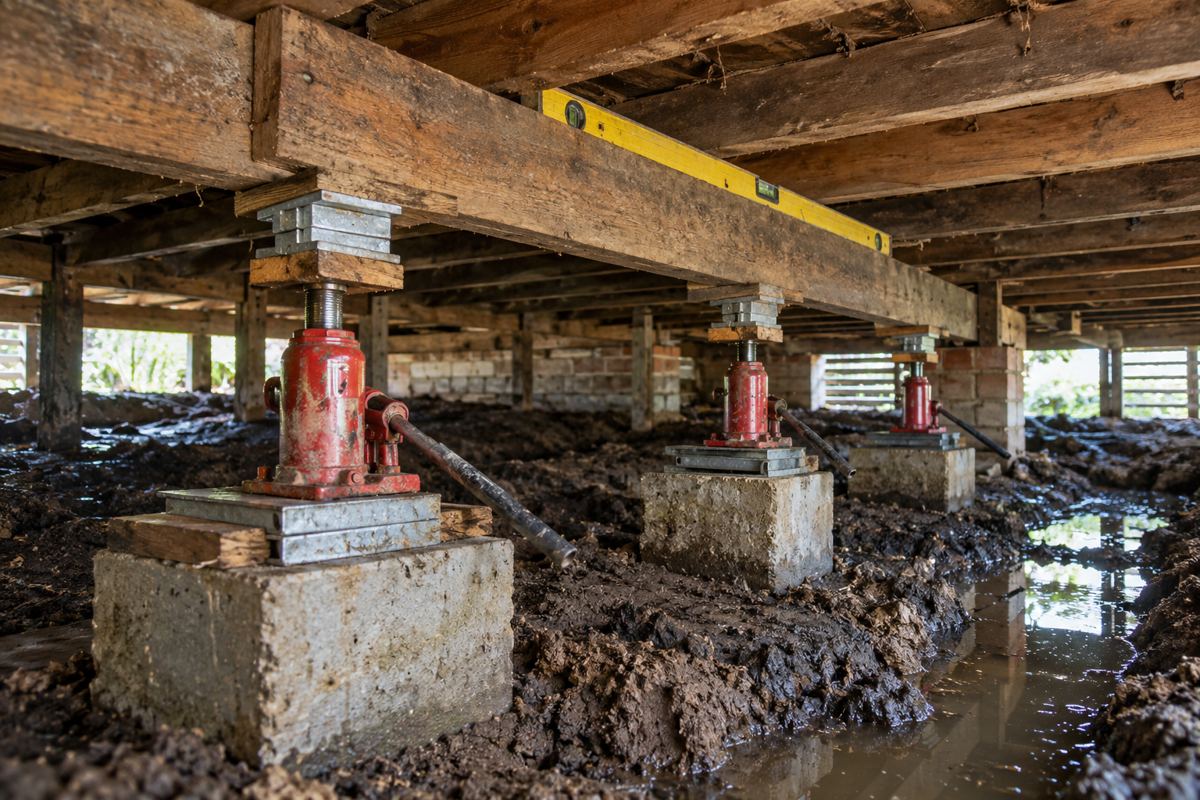
The climate on top of it
The Bureau of Meteorology's Cerberus station records a mean annual rainfall of 712.8 mm over 1986 to 2026, on 105.5 rain days, with June the wettest month at 73.5 mm and February the driest at 34.8 mm. Mean maximum temperature is 19.2 degrees and mean minimum 9.9. The older Cranbourne Botanic Gardens record, closed in 2020, averaged 811.9 mm on 115 rain days, which is a fair guide to the wetter northern edge. The pattern is what matters more than the total: winter wet, summer dry. On clay that means a swell-and-shrink cycle every year. On sand it means a dry subfloor most of the year and a burst of water through the dunes when it does rain, which is when loose sand moves.
Timing follows from the pattern. On the clay country, late summer and autumn are the months to restump: the holes stay dry, the clay is at its driest, and the house is at its lowest point, which is the right point to level from. On the sand, the season matters less for the digging and more for the traffic, which is why an empty holiday house in spring is the easy job. Either way, a subfloor inspection in August shows the house at its wettest, which is a useful time to see where the water goes.
Slope and landslip
The Arthurs Seat unit is granite under sandy gritty loam, with shallow soils on steep slopes at Arthurs Seat and Mount Martha. A house on a slope there sits on a platform cut into the hill on one side and built up on the other, with short stumps uphill and tall stumps downhill in fill. The Peninsula has had its slopes move in recent years. On 29 September 2020 about 30 tonnes came down onto The Esplanade at Mount Martha and two access roads have been closed since, with retaining wall works running from November 2025 to December 2026. In November 2022 Mount Martha North beach was closed near the beach boxes after a cliff was assessed as unsafe. On 14 January 2025 a landslide at McCrae brought down a house on Penny Lane, and the Board of Inquiry delivered its final report on 9 September 2025. The Shire's response was the interim EMO7 landslide overlay, since narrowed by Amendment C314morn. On a sloping block in any of those areas, underpinning and deep restumping are a job for an engineer before a restumper, and the overlays page explains the planning side.
What nobody can tell you from the street
The site class of a block under AS 2870, the residential slab and footing standard that sorts ground from stable to highly reactive, comes from a soil test by a geotechnical engineer, not from the suburb or the VRO map. This site does not assign a class to any Peninsula town and no page should. Where a job depends on the class, which underpinning always does and deep restumping on the clay or the peat sometimes does, the engineer orders the test and the soil test classifies the site. What the map does tell you is what kind of question to ask: on the Cups and Rosebud sand, ask what the stump stands on; on the Bittern, Dromana and Hastings clay, ask how deep and how it drains; on Arthurs Seat granite, ask about the slope; at Tootgarook, ask the engineer first.
A soil test is not a large job. An engineer or a geotechnical firm takes a bore or two to the depth the footing will reach, logs what comes up, and classifies the site. The stump or underpinning design follows from the class, and the surveyor expects to see both before issuing a permit for underpinning. For an ordinary restump on sound ground the builder works to what the inspection and the holes show, and the surveyor decides whether a test is wanted; on the sloping ground in an erosion overlay, or on the peat, it usually is. Either way the sequence is the same: ground first, design second, stumps last.
What soil knowledge cannot do
It cannot classify your block; a geotechnical test does that, and this site assigns no AS 2870 class to any town. It cannot predict a wet winter, which is what moves the clay, or a summer storm, which is what moves the sand. It cannot tell you whether the stumps under a particular house have rotted or leaned, because that is an inspection with a torch. It cannot tell you whether a sloping block is still inside the EMO7 overlay after Amendment C314morn; the Shire can. And it cannot change the ground, which is why the answer on clay is depth and drainage, on sand a proper base, and on peat an engineer.
Check the current rules before you rely on this
This page summarises published descriptions of the soils, climate and landslip history of the Mornington Peninsula as they affect house stumps and footings. It describes the rules in general terms as they stood in October 2026. Standards, forms, thresholds and fines change.
The authoritative sources are Victorian Resources Online, soil and landform units of the Mornington Peninsula, Victorian Resources Online, Cups soil unit, Victorian Resources Online, Hastings soil unit, Bureau of Meteorology climate statistics, Cerberus, Mornington Peninsula Shire, landslide susceptibility and the Erosion Management Overlay and Mornington Peninsula Shire, McCrae landslide. Where anything here differs from those sources, they are right and we are not.
We are not building surveyors, engineers, planners or lawyers. For what applies to your house, ask a registered building surveyor or ring Mornington Peninsula Shire on 1300 850 600.
Accurate at the time of writing, October 2026. Always check the source before relying on it.