The Western Port side
Hastings, Somerville, Tyabb, Baxter, Bittern, Crib Point, Somers, Balnarring and the coast down to Flinders and Shoreham are the other Peninsula: Western Port rather than Port Phillip, flat rather than dune, and clay rather than sand. The Shire's Open Space Strategy records medium density housing at 26 per cent in Hastings, the highest in the Shire against 12 per cent overall, and the holiday-house share is lower here than on the bay side except along the southern coast, where Flinders, Shoreham and Point Leo had 45.6 per cent of dwellings empty on census night 2021. The Shire's thematic history describes the post-war housing estates and holiday houses that urbanised the Peninsula, and the weatherboards and fibro of that era sit on timber stumps across these towns, many of them on ground that is wet from June to September every year.
The work here is reblocking with drainage built in rather than added, and relevelling on houses whose stumps are sound but whose floors have followed the clay down. On the alluvial flats a hole dug in winter has water in it before the old stump is out, and a new timber stump would stand in the same water as the old one.
The ground: the wettest on the Peninsula
| Unit | Where | What it means for stumps |
|---|---|---|
| Hastings unit | The near-level alluvial plains around Hastings | Poor drainage, surface water in wet periods, medium to heavy clay from 300 to 400 mm. Stumps stand in water in winter. The holes are wet, the clay moves with the seasons, and drainage is part of every job, not an extra. |
| Bittern unit | Baxter, Hastings and the north and west of the Peninsula | Fine sandy loam over a bleached zone with ironstone, medium clay from about 350 mm, sodic subsoils, waterlogging in wet periods. Timber rots at the ground line; cracks open in late summer and close in spring. |
| Dromana unit | Across toward Baxter from the Mount Martha side | Sandy loam over a bleached subsurface, mottled medium clay from about 450 mm. The stump has to reach the clay and sit on it properly. |
The Hastings unit is the one that decides most jobs here. Near-level ground does not shed water, and poor drainage means the water that falls in June is still under the house in August. The Bureau of Meteorology's Cerberus station averages 712.8 mm a year with 105.5 rain days, June the wettest at 73.5 mm and February the driest at 34.8 mm; the older Cranbourne Botanic Gardens record to the north averaged 811.9 mm on 115 rain days before it closed in 2020. The pattern is winter-wet and summer-dry, which on medium to heavy clay means the ground swells under the house for three months and shrinks for three. The Bittern unit around Baxter and the northern edge adds sodic subsoils, which disperse when wet and set hard when dry. Neither is ground a timber stump lasts in. The soils guide goes through both, and the soil test classifies the site where a job depends on it.
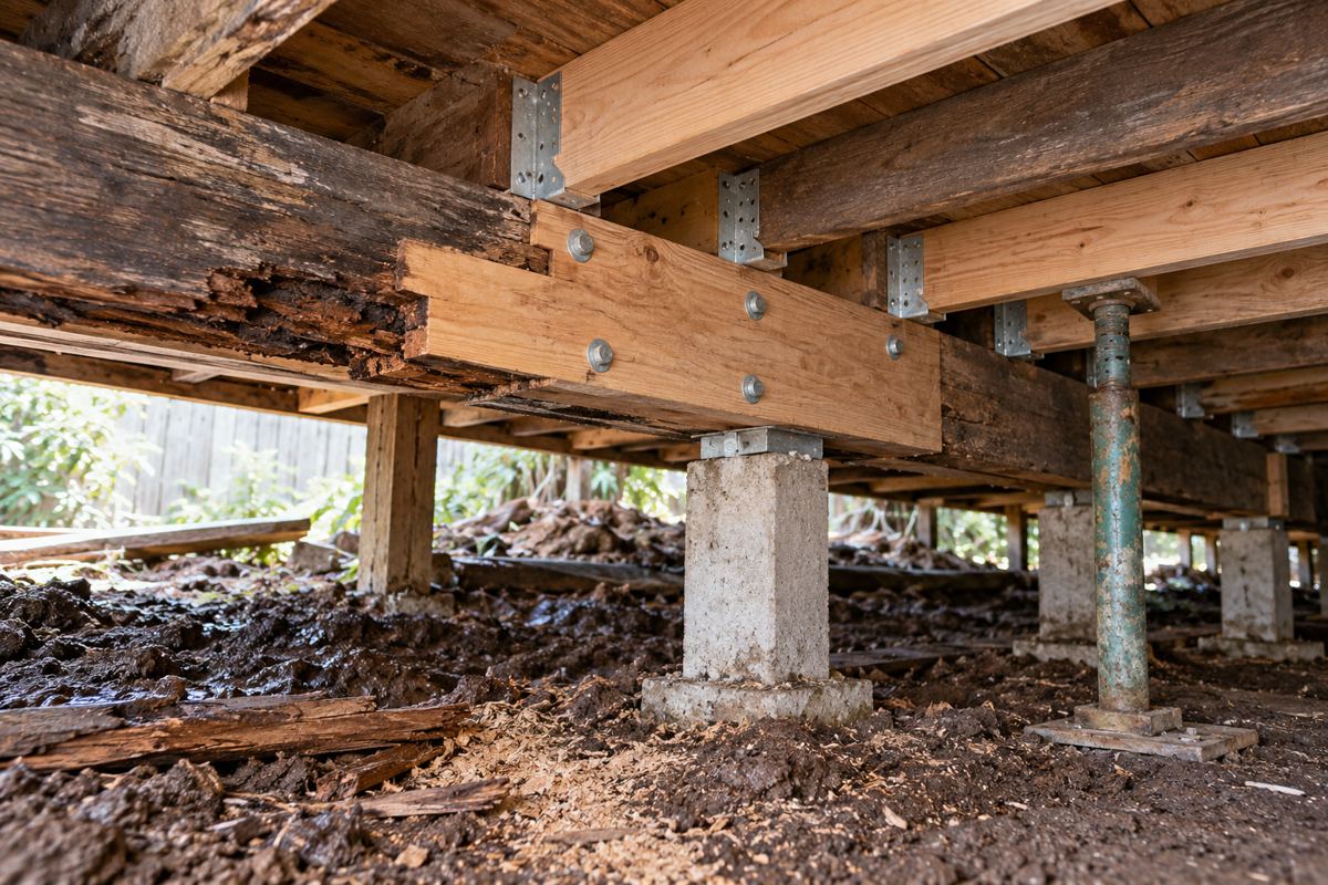
What a Western Port job usually looks like
- A weatherboard on the Hastings flats. Timber stumps rotted at the ground line, tide marks at the same height on every stump, bearers soft at the wet corner. Full restump in concrete or steel set deeper with wider pads, bearers replaced to sound timber, the ground under the house regraded, vents on every side and an agricultural drain to a legal point of discharge where the fall allows.
- A post-war fibro at Somerville or Tyabb. Mixed stumps, a laundry or sleep-out on its own shallow stumps that went first, packing from a past relevel. Full or partial restump depending on the count, drainage on the low side.
- A brick veneer on stumps at Bittern or Crib Point. A dropped corner and a stepped crack above it. Careful relevel or partial restump with small lifts so the brickwork is not stressed. On a strip footing it is underpinning instead, on an engineer's design, after the drainage.
- A holiday house at Somers, Balnarring, Shoreham or Flinders. Shut up for most of the year, vents blocked, a subfloor nobody has looked at. Inspection first, and on the coast, a check of the EMO6 position.
- A house on the clay that has been relevelled before. Stacks of timber or tile packing between stump and bearer, the floor level for a season after each lift and then down again. Packing is a sign the stumps under it were never deep enough for the clay; the fix is stumps, not more packing.
On the flats the drainage is not a line at the bottom of the quote, it is the reason the rest of the quote holds. Regrading the ground under the house so water runs out rather than in, vents on every side so the subfloor dries between winters, downpipes connected rather than discharging at a corner, and where the block has fall, an agricultural drain along the wet side to a legal point of discharge. The drainage page covers what goes in and where. A quote that does not mention any of it, on the Hastings plains, is a quote for new stumps standing in the old water.
Timing on the flats
Late summer and autumn, for the same reason as everywhere on the clay but more so. The Cerberus record puts June at 73.5 mm and February at 34.8 mm, and on near-level ground with poor drainage the water that falls in June is still under the house in August. A hole dug beside a Hastings stump in winter fills before the old stump is out, and the crew pumps, waits and digs again. The same hole in March is dry, the clay is at its driest and the house is at its lowest point, which is the right point to level from. The one thing winter is good for is the inspection: an hour under the floor in August shows where the water sits, which stumps stand in it and where the drain needs to run.
EMO6, bushfire and the Green Wedge
The planning scheme's Erosion Management Overlay EMO6 runs along the Western Port coast from Somerville to Cape Schanck, and EMO5 covers the Flinders township. Building and earthworks in an EMO area may need a planning permit and a landslide risk assessment by a qualified engineer or geologist. The interim shire-wide EMO7 of January 2026 was narrowed by Amendment C314morn on 19 October 2026 to about 6,000 properties, and the field inspection areas it names are on the Port Phillip side and in the hinterland rather than on the flats, so for most of Hastings and Somerville the question is EMO6 on the coast and not EMO7; ask the Shire for a particular lot. About 70 per cent of the Shire is Green Wedge, and the Western Port towns sit in it more than most, with bush and paddock at the back fence. In a Bushfire Prone Area, alterations and additions must meet AS 3959 with the BAL assessed at building permit stage; a restump alone rarely changes anything, but the surveyor says whether the subfloor is affected.
Heritage Review Area 4
The Western Port side is the last part of the Peninsula to get its heritage review. Amendment C302morn proposes 58 new Heritage Overlay places plus 15 others across Balnarring, Bittern, Crib Point, Flinders, Hastings, Main Ridge, Red Hill, Shoreham, Somers, Somerville and Tyabb. It is on exhibition from 29 October to 11 December 2026 and there are no interim controls, so a house on the proposed list has no new planning requirement until the amendment is approved. Coolart at Somers is already on the Victorian Heritage Register and needs Heritage Victoria's approval separately from the Shire. If your house is on the exhibited list, the sensible move is to ask the Shire's heritage team at [email protected] before planning anything that changes the outside, and to get the stumps done like for like while the position is clear. The overlays page explains the Heritage Overlay position in full.
Flood prone land and the rules
A large percentage of the Shire is designated flood prone, and the near-level alluvial plains with surface water in wet periods are where that designation is most likely to matter. This site has not verified the flood mapping for Hastings or Somerville street by street, so the sequence is the standard one: the surveyor tells you whether your lot is flood prone, the property information certificate (regulation 51(2), $53.62 in 2025-26) says so in writing, and building work on it needs the Shire's report and consent under regulations 153 and 154 at $329.60 per regulation in 2025-26, with a Melbourne Water response and plans showing AHD levels. The rest is the same as everywhere on the Peninsula: a building permit from a private registered building surveyor, a builder registered with the Building and Plumbing Commission at any value, a written contract over $10,000, Home Warranty insurance over $20,000, and a Shire designated termite prone from end to end. The permits page has the detail.
What cannot be fixed on the flats
The water table and the drainage. A house on the Hastings plains will have a wet subfloor in winter whatever is done, and the aim is stumps that do not mind and drainage that keeps the water from pooling. The clay. It will move; deeper stumps, wider pads and adjustable heads manage it, they do not stop it. The flood designation, which the Shire's certificate states and the surveyor works to, whatever a page like this guesses. And the heritage review, which is on exhibition and not yet law, so nobody can say today what C302morn will mean for a particular house in Hastings or Somers when it is approved.
Check the current rules before you rely on this
This page describes restumping on the winter-wet clay plains and Western Port coast around Hastings, Somerville, Tyabb and the southern coast towns. It describes the rules in general terms as they stood in October 2026. Standards, forms, thresholds and fines change.
The authoritative sources are Victorian Resources Online, Hastings soil unit, Victorian Resources Online, Bittern soil unit, Bureau of Meteorology climate statistics, Cerberus, Mornington Peninsula Shire, landslide susceptibility and the Erosion Management Overlay, Mornington Peninsula Shire, Amendment C302morn heritage review Area 4 and Mornington Peninsula Shire, report and consent to build on flood prone land. Where anything here differs from those sources, they are right and we are not.
We are not building surveyors, engineers, planners or lawyers. For what applies to your house, ask a registered building surveyor or ring Mornington Peninsula Shire on 1300 850 600.
Accurate at the time of writing, October 2026. Always check the source before relying on it.